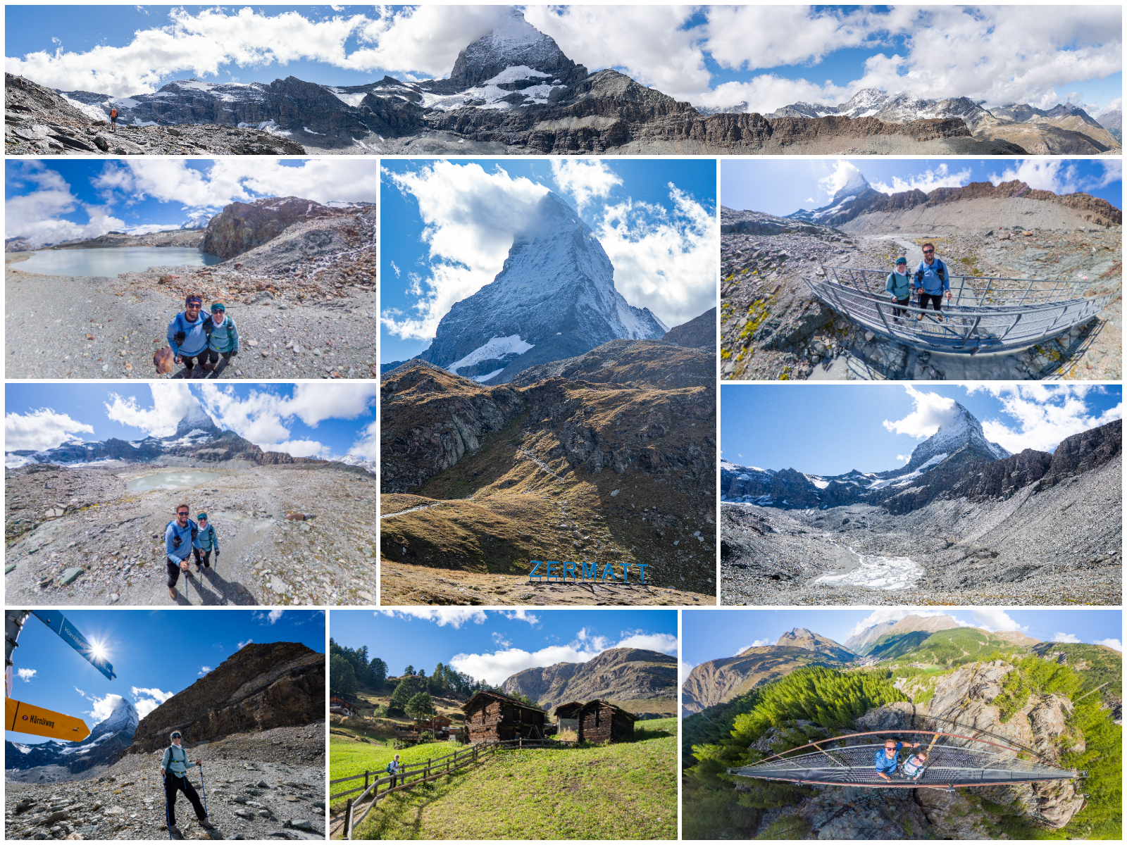
Our time in Zermatt tested both patience and flexibility as the Matterhorn played hide-and-seek behind stubborn clouds. For our last full day, we had planned to hike up to the Hörnlihütte base camp, the Matterhorn’s iconic mountain hut, for what would have been our most demanding hike of the trip. But with low visibility in the morning, we spent hours watching webcams and waiting for the skies to clear. By the time the fog began to lift, we made the call to skip the steep Hörnlihütte ascent and instead focus on the Matterhorn Glacier Trail – and it turned out to be the right decision. Dressed warmly, we rode the gondola up to Trockener Steg at nearly 10,000 feet and stepped into a stark, otherworldly landscape of gray rock and glacial ice, hiking toward the shadowed face of the Matterhorn that seemed close enough to touch. We paused at a scenic spot for a snack, waiting nearly an hour for the clouds to break, and though the summit never fully revealed itself, the drama of the shifting light made it unforgettable. As afternoon turned late, we hurried down toward Schwarzsee, catching the gondola partway and making a quick detour in Furi to cross the suspension bridge, a fun and scenic bonus before the day’s final dash. Racing against the clock for the last gondola, we narrowly avoided getting stranded – thanks to a kind guard who let us ride the freight cable car back down to Zermatt. That evening, we celebrated our alpine adventure with fondue at sunset at Old Zermatt, just steps from the Kirchbrücke Bridge, as the Matterhorn glowed gold and rose in the fading light – an unforgettable finale to our time in Switzerland.
🗓️ Itinerary
This plan came from our August 30, 2025 visit (Day 11), based in Zermatt.
❄️ Matterhorn Glacier Trail
- 🚶♂️ Stroll around Zermatt due to poor weather/Matterhorn visibility
- 🚠 12:00 AM – Transit: Zermatt → Matterhorn Glacier Paradise (1h)
- 🚶♂️ 12:00 PM – Walk (15m) to Zermatt Matterhorn Talstation
- 🎟️ BOOK tickets at ticket booth for entire route up to get Half-Fare discount. Book return routes as well if you are sure of your itinerary.
- 🚠 12:15 PM – Gondola: Zermatt (Matterhorn Talstat)→ Furi (8m, every 1m from 8:30 AM – 3:41 PM)
- 🚠 12:25 PM – Gondola: Furi → Zermatt Schwarzsee (9m, every 1m from 8:30 AM – 3:51 PM)
- 🚠 12:36 PM – Gondola: Zermatt Schwarzsee→ Trockener Steg (11m, every 1m from 8:30 AM – 4:02 PM, 49 CHF before Half-Fare)
- 💡 Sit on the right for Matterhorn views and stay on gondola all the way to Trockener Steg
- 🥾 1:00 PM – Hike Matterhorn Glacier Trail: Trockener Steg → Schwarzsee (2-3h, 4.4 mi mostly downhill)
- 🏔️ Highlights: great Matterhorn angles, alpine scenery, glacier views, moraine landscape
- ⏩ Skip the Hörnlihütte Trail Junction to continue directly on the main trail to Schwarzsee. See our original plan Hörnlihütte Ascent from Matterhorn Glacier Trail if you have time for this add-on.
- 📸 4:20 PM – Arrive at Schwarzsee and explore (⏰ time/energy dependent)
- ⛪️ Optional: Visit to the chapel and photo opportunities by the lake
- 🍽️ Optional: Snack/drink @ Restaurant Schwarzsee (Indoor or outdoor terrace seating with panoramic views of the Matterhorn and lake that serves traditional Swiss fare)
🌁 Furi Suspension Bridge Trail
- 🚠 4:30 PM – Cable Car: Schwarzsee → Furi (9m, every 1m from 8:30 AM – 4:40 PM, 🎟️BOOK tickets onsite at machine to get Half-Fare discount.💡 Be sure to check the last gondola down, otherwise you’ll have to hike 4.4 mi down to Zermatt)
- 🥾 4:40 PM – Furi Suspension Bridge Loop Hike (~45m, 1.6 mi 💡 Only recommended if it’s along your route. It is not as scenic as other hikes in the region and is mostly on gravel/road. Only do it as a backup activity and skip it if you have a full itinerary.)
- 🚠 5:30 PM – Gondola: Furi → Zermatt (Matterhorn Talstat.) (8m, every 1m from 8:30 AM – 5:30 PM, 🎟️ BOOK tickets onsite at machine to get Half-Fare discount,💡 Be sure to check the last gondola down. We missed it but fortunately the operator took us down in his special cable car. It’s a 2.2 mi hike down via Zum See and Blatten.)
- 🧺 Pick up picnic lunch for Aug 31 (Coop grocery)
- 🍽️ 8:00 PM – Dinner @ Old Zermatt (🎟️ RESERVE 🏔️ Chalet with Matterhorn views from terrace and traditional Swiss fare.)
💡 Tips
- 🌦️ Check weather before committing – Check MeteoSwiss app and Zermatt.ch webcams (Matterhorn Glacier Paradise, Trockener Steg and Hirli). The Matterhorn was in full clouds in the morning, and we adjusted our itinerary to cut Matterhorn Glacier Paradise and Hörnlihütte, starting the Matterhorn Glacier Trail in the afternoon. This paid off with the Matterhorn coming out of the clouds towards the end of our hike.
- 🎟️ Buy tickets at the counter – Purchase round-trip tickets in person to ensure you get your Half-Fare Card discount and secure your return. The staff can also confirm trail conditions and last gondola times.
- 🧥 Bundle up – Even in summer, the Trockener Steg (2,939 m) is chilly. Bring gloves, a hat/gaiter, and a jacket.
- 🥾 Hike downhill for easier terrain – The Matterhorn Glacier Trail from Trockener Steg to Schwarzsee is mostly downhill on rocky terrain. Hiking poles help with loose gravel and uneven footing.
- ❄️ Glacier Paradise optional – Only go up to Klein Matterhorn (3,883 m) if skies are clear. It’s very pricey and has similar glacier views as Schilthorn or Jungfraujoch.
- 🕓 Check last gondola times carefully – The final descent from Schwarzsee is typically 4:40 PM and from Furi is 5:30 PM – missing it means a long, steep walk down of 4.4 or 2.2 mi, respectively.
- 🚶♂️ Skip Furi Suspension Bridge – It’s fine as a backup, but the scenery isn’t as impressive as other hikes. Prioritize rest or town exploring instead.
- 🧺 Coop groceries – Purchase picnic supplies for the next day before store closes at 7 PM.
📸 Summary
🚠 Trockener Steg
Take the Matterhorn Express gondola from Zermatt up to Trockener Steg, staying seated through Furi and Schwarzsee for the full ascent. The ride climbs high above forests, waterfalls, and alpine meadows before giving way to stark, glacial terrain that feels almost lunar. As the gondola nears the upper station, the Matterhorn suddenly dominates the skyline, its jagged summit towering over a landscape of rock, snow, and shifting clouds. Stepping out at nearly 3,000 m, the air feels thinner, the temperature drops, and you’re surrounded by a panorama of rugged peaks and ancient ice that sets the stage for an unforgettable Matterhorn Glacier Trail hike.


❄️ Matterhorn Glacier Trail
The Matterhorn Glacier Trail is a rugged but rewarding high-alpine route that feels like walking on another planet. Starting at Trockener Steg, the path descends through a dramatic landscape of rock, ice, and moraine left behind by the retreating Theodul Glacier. Despite being downhill, the terrain is rocky and uneven, demanding sure footing and hiking poles for stability. We waited until after noon to begin the hike, holding out hope the clouds would lift – and they finally did! After nearly an hour of watching the sky shift, the Matterhorn emerged from behind the clouds, rewarding our patience with its iconic pyramid peak in full view. Because of the late start, we cut the Matterhorn Glacier Paradise and Hörnlihütte ascent from our plan and stuck to the main trail down to Schwarzsee. When visibility is clear, the views are spectacular – the Matterhorn looms dramatically above glacial valleys. While the trail to Schwarzsee lacks much vegetation or shade, its stark alpine character makes it one of Zermatt’s most unique hikes, especially if you want to feel close to the Matterhorn without the crowds.
📈 Hiking Stats
Time: 1:32 moving, 3:23 elapsed to allow photos and ~1h wait for Matterhorn to emerge from clouds
Distance: 4.4 miles (7 km)
Max Elevation: 9,610 ft
Cumulative Ascent: 547 ft
Cumulative Descent: 1,704 ft
Difficulty: Easy
Directions: Take the Matterhorn Express gondola from Zermatt up to Trockener Steg, staying seated through Furi and Schwarzsee for the full ascent. Once at Trockener Steg, follow the “Matterhorn Glacier Trail” signs downhill past Theodulgletschersee toward Schwarzsee. Stop for the most panoramic views on the Furggbach Bridge (at ~2.9 mi). Skip the Hörnlihütte Trail Junction (at ~3.5 mi) to stay on the main route, which descends steadily past glacial moraine fields and viewpoint markers explaining the area’s geology. When the path diverts, be sure to take the upper dirt path to the right (rather than the gravel path) for a more scenic hike. The trail ends at Schwarzsee, where you can take a picture with the Zermatt sign, rest by the lake, visit the small chapel, or grab a drink at Restaurant Schwarzsee before continuing down via gondola. Check the last gondola departure from Schwarzsee (typically around 4:40 PM) before starting, since missing it means a 4.4 mi hike down to Zermatt on steep, rocky paths.
Additional Resources: Garmin Data, All Trails, Earthtrekkers, Hörnlihütte Ascent from Matterhorn Glacier Trail

🌊 Theodulgletschersee
Not long after leaving Trockener Steg, the trail passes Theodulgletschersee, a small glacial lake fed by meltwater from the Theodul Glacier. Unlike the vivid turquoise lakes found lower in the Alps, this one is a muted grey-blue, colored by fine silt and rock flour suspended in the icy water. The lake sits in a stark, rocky basin surrounded by moraine and scree, where the landscape feels raw and untouched – more lunar than alpine. On clear days the Matterhorn reflects faintly on the silvery surface.


🏔️ Matterhorn Emerges Near Furggbach Bridge
Just before reaching the Furggbach Bridge, the trail passes a small, glassy lake nestled among the moraine – a quiet spot that perfectly captures the mood of the high alpine landscape. We decided to pause here, hoping the Matterhorn would finally clear after hiding behind clouds most of the day. For nearly an hour, we watched the sky shift and brighten, the clouds thinning just enough to reveal the mountain’s snowy shoulders and sharp outline, though its summit stayed partly veiled. By the time we reached the Furggbach Bridge, the Matterhorn peeked through the haze, framed beautifully above the glacial valley and the milky-blue stream rushing beneath our feet. Even without a completely clear view, the moment was unforgettable – raw, dramatic, and unmistakably Zermatt.


🔁 360 Photos
⏎ Hörnlihütte Trail Junction
Just below Trockener Steg, the Hörnlihütte Trail Junction (at ~3.5 mi) marks a major decision point – whether to turn uphill toward the climbers’ base camp or continue down along the Matterhorn Glacier Trail. This was originally our plan for the day – see Hörnlihütte Ascent from Matterhorn Glacier Trail. However, weather delays meant adjusting our route and heading downhill to Schwarzsee. The turnoff leads to the Hörnlihütte perched at 3,260 m, a steep and demanding climb with closeup views of the Matterhorn, while the main trail offers a gentler descent through glacial valleys, moraine ridges, and meltwater streams carved by the Theodul Glacier.


🌊 Schwarzsee
By the time you reach Schwarzsee, the rugged rock gives way to alpine meadows and soft trails surrounded by wildflowers and grazing cows. The small lake perfectly mirrors the Matterhorn on calm days, with a tiny white chapel perched on the shore – a serene reward after the descent. Near the lake, you’ll also find the large “Zermatt” sign, a fun photo spot that perfectly frames the Matterhorn in the background. Since we started the hike later in the day, we didn’t have much time to linger here and had to move quickly to catch the last gondola down. Whether you stop for a drink at Restaurant Schwarzsee or simply sit by the water taking in the view, it’s the ideal place to rest your legs and soak in one last moment of mountain magic – if time allows – before descending back toward Zermatt.


🌁 Furi Suspension Bridge Trail
The Furi Suspension Bridge “Hängebrücke” Loop is a short hike that starts and ends near the Furi gondola station, crossing a steel bridge suspended over the Gorner Gorge. The bridge itself is fun to experience – gently swaying over rushing water far below – but the surrounding route is mostly on gravel roads and forest tracks, offering limited alpine scenery compared to Zermatt’s other trails. It’s best treated as a backup activity or a pleasant add-on if you’re already passing through Furi and have spare time. It’s still a neat spot for a few photos and a quick adrenaline boost if you want to stretch your legs before heading back to Zermatt.
📈 Hiking Stats
Time: 33:29 moving, 45:21 elapsed to allow photo stops
Distance: 1.8 mi (2.9 km)
Max Elevation: 6,446 ft (1,965 m)
Cumulative Ascent: 434 ft (132 m)
Cumulative Descent: 475 ft (145 m)
Difficulty: Easy
Directions: From the Furi gondola station, follow signs for the “Hängebrücke” (Suspension Bridge) trail. The loop can be done in either direction, but the best route is counterclockwise, starting along the path through Furi, then cutting across to the bridge itself. You’ll reach the bridge a little after 0.5 mi, where you can pause to take in the panoramic view into the gorge before crossing. Afterward, follow the mostly downhill wooded trail back to the Furi gondola station. Confirm the last gondola down to Zermatt before starting (typically 5:30 PM) – if you miss it, you’ll have to hike ~2.2 mi down to Zermatt.
Additional Resources: Garmin Data, All Trails

🌁 Furi Suspension Bridge “Hängebrücke”
The Furi Suspension Bridge (Hängebrücke) is a sleek steel span stretching about 100 meters across the Gorner Gorge, suspended roughly 90 meters above the glacial waters below. Built to connect the small alpine hamlets near Zermatt and enhance access between the trails around Furi and Blatten, it blends modern engineering with mountain utility, using metal grates and tensioned cables anchored deep into the rock. Crossing it is a fun experience – the bridge sways gently with each step, and the sound of the rushing Gornera River echoes through the gorge beneath your feet.


Other Videos: YouTube Short
🏡 Furi Hamlet
Tucked into the forested slopes above Zermatt, Furi is a peaceful little alpine hamlet that serves as a key gondola hub and gateway to several scenic trails. Unlike the bustling streets of Zermatt below, Furi feels calm and rustic – a cluster of wooden chalets, grazing pastures, and mountain restaurants surrounded by pine trees and distant glacier views. It’s the perfect midpoint between the high alpine world of Trockener Steg and the valley floor, offering easy access to hikes like the Furi Suspension Bridge Loop, Zum See, and Blatten. Small, quiet, and charming, Furi captures the simple, slow-paced rhythm of mountain life that makes the Zermatt region so special.


🚠 When You Miss the Gondola & Hitch a Rescue Ride with the Guard
We almost ended our adventure with an unexpected night hike back to Zermatt after realizing we were racing the clock for the last gondola from Furi. It did not look like we would make it, so we started running while Scott booked the tickets on his phone. When we reached the station it was past opening hours and eerily empty, so we slipped past the barricade toward a cabin when a guard ran after us, yelling. We explained we had already bought tickets and needed to get down. He told us the gondolas were only still moving to bring the last riders all the way back to Zermatt, and if we had boarded, the line would have stopped mid-air before we reached town. Thankfully he was sympathetic and ushered us onto the giant freight cable car instead, and we glided down in a quiet, behind-the-scenes rescue ride, making it back to Zermatt in time for dinner.
💡 Always double-check the last gondola times, especially at Furi, since they vary by season and missing it means a 2.2-mile downhill trek to Zermatt on steep, rocky trails you probably will not enjoy after a full day of hiking.


Original Plans Cut Due to Weather and Time
🧗 Hörnlihütte Ascent from Matterhorn Glacier Trail
Our original plan was to hike from Trockener Steg to Hörnlihütte, the legendary base camp for Matterhorn climbers, before continuing down to Schwarzsee. The full route would have covered 8.3 mi (~5-6 hours) with a steep +400 m ascent to Hörnlihütte (3,260 m / 10,700 ft), offering a close-up look at the climbers’ approach route and jaw-dropping Matterhorn views from the hut’s terrace. However, the weather forced a change in plans. Low clouds completely obscured the peak for most of the morning, so we waited until after noon to start hiking in hopes it would clear. By the time the Matterhorn finally appeared, it was too late in the day to safely attempt the steep ascent. Instead, we chose to skip the Hörnlihütte segment and continue along the Matterhorn Glacier Trail directly to Schwarzsee, trading the summit-style climb for a more relaxed, scenic descent. While it would’ve been incredible to stand at the Matterhorn’s base camp, the visibility and timing just didn’t align – and honestly, watching the mountain slowly emerge from the clouds was its own kind of magic.
- 🥾 Hike: Trockener Steg → Hörnlihütte Trail Junction → Hörnlihütte → Schwarzsee (5-6h, 8.3 mi, +400m/-1040m)
- ❄️ 9:00 AM – Segment 1: Trockener Steg → Hörnlihütte Trail Junction (❓Decide) → Hörnlihütte Summit OR Return via Schwarzsee
- This is part of the Matterhorn Glacier Trail
- 1-2h (gentle descent with glacier views), 3.5 mi, -300m (from 2,939m to 2,640m) elevation loss
- 💡 This junction is before the trail would otherwise continue to Schwarzsee, so you’ll be turning uphill at this point.
- 🧺 Lunch: Picnic along hike
- 🏔️ 11:00 AM – Segment 2: Hörnlihütte Trail Junction → Hörnlihütte (⏰ time/energy/altitude acclimation dependent, 💡 Earthtrekkers tips)
- 1-2h, 2 mi, +400 m (+1,312 ft) elevation gain
- Steady, steep alpine path to Matterhorn base camp (elevation 3,260m / 10,700ft). Incredible up-close views of the Matterhorn and climbers preparing for summit attempts.
- ❄️ Weather: 28-48°F (morning to midday). Cold wind chill – even on sunny days, strong winds can make it feel much colder. Rapid weather shifts – clear mornings can turn cloudy or stormy by afternoon. Snow patches may still exist, especially near Hörnlihütte or shaded ridges. Sun is intense – high UV.
- 🧳 What to Wear: Insulated layers (fleece or down jacket), windproof outer shell, hat and gloves (yes, even in August), sturdy hiking shoes, sunglasses & sunscreen
- 🍽️ 1:00 PM – Arrive at Hörnlihütte and snack break @ Hörnlihütte Restaurant with terrace views
- ↘️ 2:00 PM – Segment 3: Hörnlihütte → Schwarzsee
- 1-1.5h, 3 mi, -740m (-2,428 ft) elevation loss
- Downhill and sometimes steep, can be slippery if wet
- 📸 3:00 PM – Arrive at Schwarzsee and explore (⏰ time/energy dependent)
- 🚠 4:00 PM – Cable Car: Zermatt Schwarzsee → Zermatt (19m, every 1m from 8:30 AM – 4:40 PM)
- ❄️ 9:00 AM – Segment 1: Trockener Steg → Hörnlihütte Trail Junction (❓Decide) → Hörnlihütte Summit OR Return via Schwarzsee
❄️ Matterhorn Glacier Paradise (Klein Matterhorn)
The Matterhorn Glacier Paradise is the highest cable car station in Europe at 3,883 m (12,739 ft), perched atop the Klein Matterhorn with 360° views stretching across Switzerland, Italy, and France. The 3S gondola ride from Trockener Steg soars above massive glaciers and icy crevasses. At the top, visitors can step out onto the panoramic observation deck for alpine views, wander through the Glacier Palace filled with shimmering ice tunnels and sculptures, and warm up with a drink at the summit café. There’s also a small Cinema Lounge showcasing short alpine films and exhibits about mountain life. However, the visit is highly weather-dependent – if clouds obscure the Matterhorn, the views (and high ticket price) are likely disappointing. Because visibility was poor during our trip, we ultimately decided to skip the Glacier Paradise and focus our time on the Matterhorn Glacier Trail instead, saving both money and altitude fatigue for clearer adventures below.
- ❄️ Matterhorn Glacier Paradise (⏰ time/budget dependent. 125 CHF/person before Half-Fare discount.💡 Skip if poor visibility or you want to save money. Likely not worth the cost if you’ve done Schilthorn or Jungfraujoch.)
- 🚠 3S Gondola: Trockener Steg → Klein Matterhorn (11m, every 1m from 8:30 AM – 4:15 PM)
- 🏔️ Arrive at Matterhorn Glacier Paradise (3,883 m elevation) and explore (1-2h)
- 🏔️ 360° observation deck with panoramic views of Alps + glaciers
- ❄️ Glacier Palace with ice tunnels and sculptures
- 🎥 Cinema Lounge + alpine-themed exhibits
- ☕ Warm drink at summit café
- 🚠 3S Gondola: Klein Matterhorn → Trockener Steg (11m, every 1m from 8:30 AM – 4:15 PM)

1 Comment
[…] Matterhorn Glacier Trail + Furi Suspension Bridge (Aug […]